
THE SHIPWRECK COAST
Treacherous and fatal for many sailors.
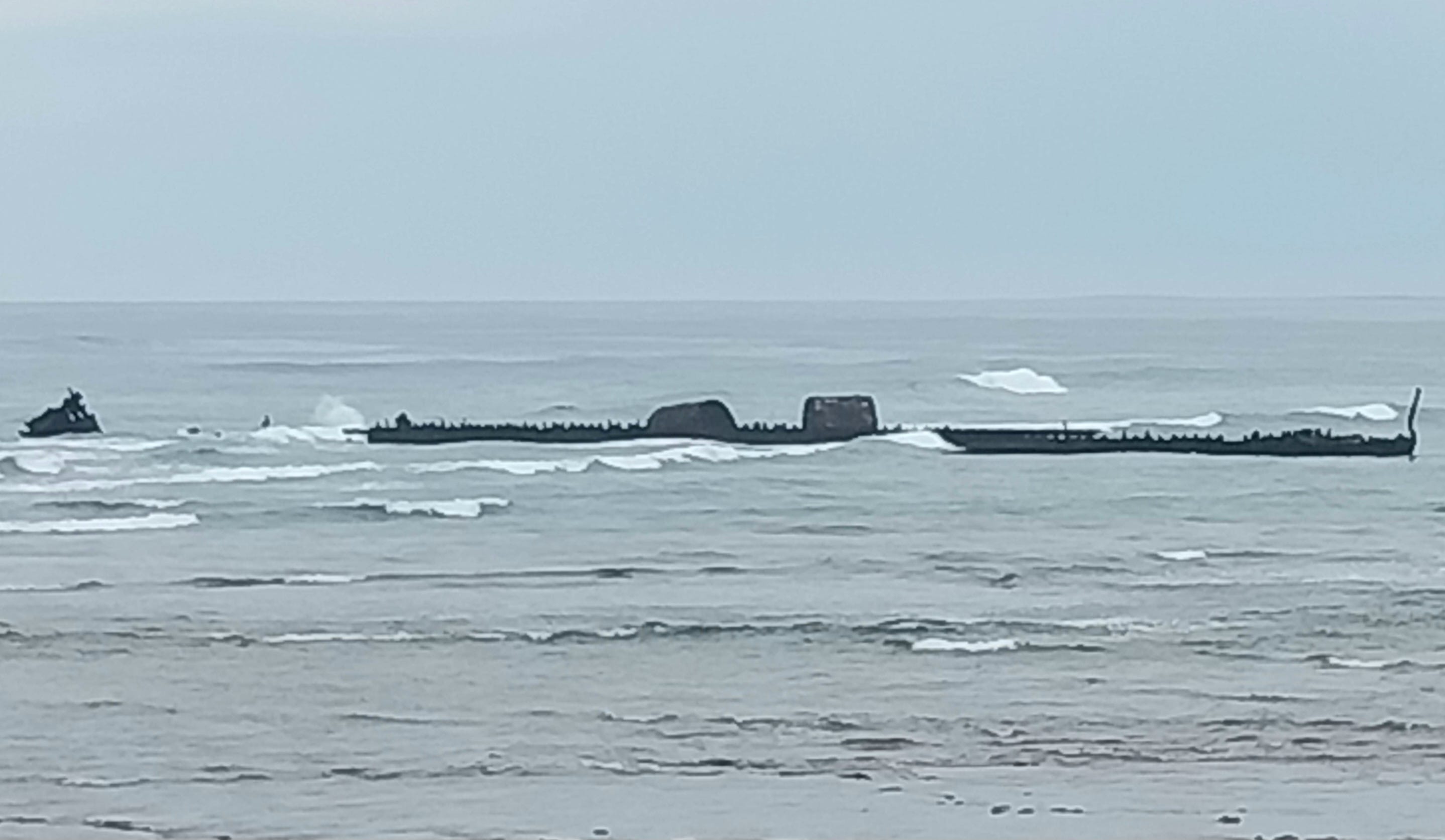
Remains of The Mildura near Exmouth. Photo: Michael Secomb.
How did the convict penal colony of Australia become one of the world’s best true democracies?
Click ‘Subscribe’, choose a free or paid subscription option and enter your details for full access.
Click ‘Michael’s Curious World’ - Posts’ for a menu of past posts in the archive.
Only costs a cup of coffee a month.
THE SHIPWRECK COAST
ABOUT 9.30pm on Tuesday, March 12, 1907 the captain of the SS Mildura, Charles Albert Thorpe, realised his ship was in great danger.
The Mildura ran into a heavy gale at full speed and slewed off course, causing a panicked reaction by Captain Thorpe.
Thorpe had safely sailed past the notorious North West Cape near modern Exmouth in Western Australia no less than 68 previous times, so he knew the area well. A later official report stated:
‘The Captain immediately went on the bridge and hauled the vessel out two points, thinking the land was Vlamingh Head. After altering the course he still saw land on the port bow, and then realised he was out of his position and instantly put the helm hard aport, but almost immediately afterwards … she struck.’ Chief Harbour Master Captain CJ Irvine, reporting to the Colonial Secretary’s Department.
The 2217-ton Mildura, built in 1901, with a crew of 36 and carrying 481 bullocks, grounded on rocks on the tip of North West Cape off Exmouth, only 80 metres from shore.
Initially the ship was not badly damaged, but could not be refloated. A boat was sent north to Onslow for help and the crew were rescued by the SS Burrumbeet.
The only hope of saving the cattle was to force them overboard, but most drowned trying to swim to shore. Salvaged timber and iron were later used to renovate the nearby Yardie Creek homestead. The wreckage was also used for bombing practice in World War II.
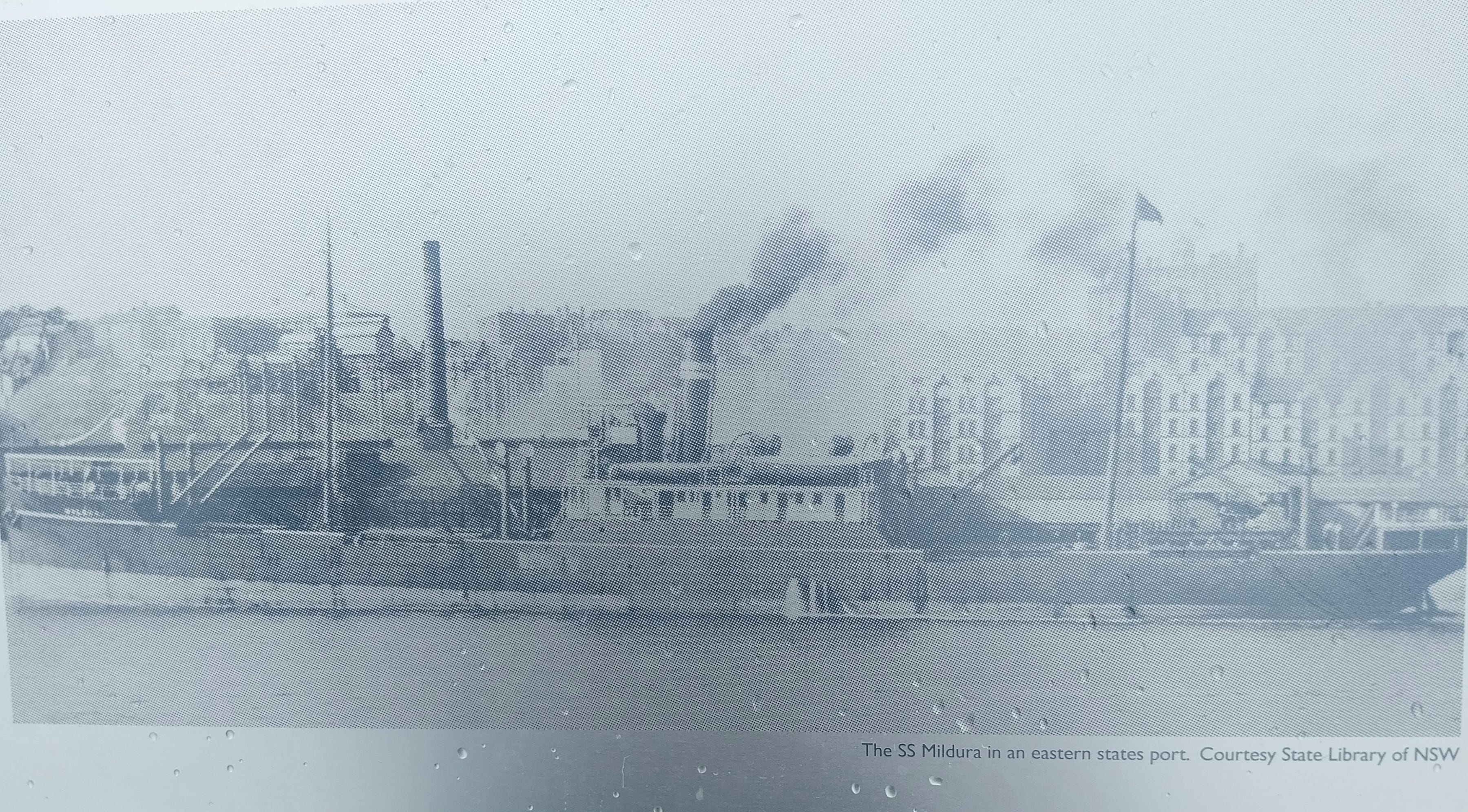
The SS Mildura before it was wrecked.
The wrecking of the Mildura happened just one day before the West Australian Government was due to submit a list of proposed lighthouses to the Commonwealth Government for funding. Vlamingh Head had not been on that list, but was quickly added. The lighthouse was completed on December 10, 1912.
However, ironically, the site chosen, on the high point of a headland, was too far from the water and could mislead captains about how far to sail offshore to avoid the rocks where the wreckage of the Mildura lay.
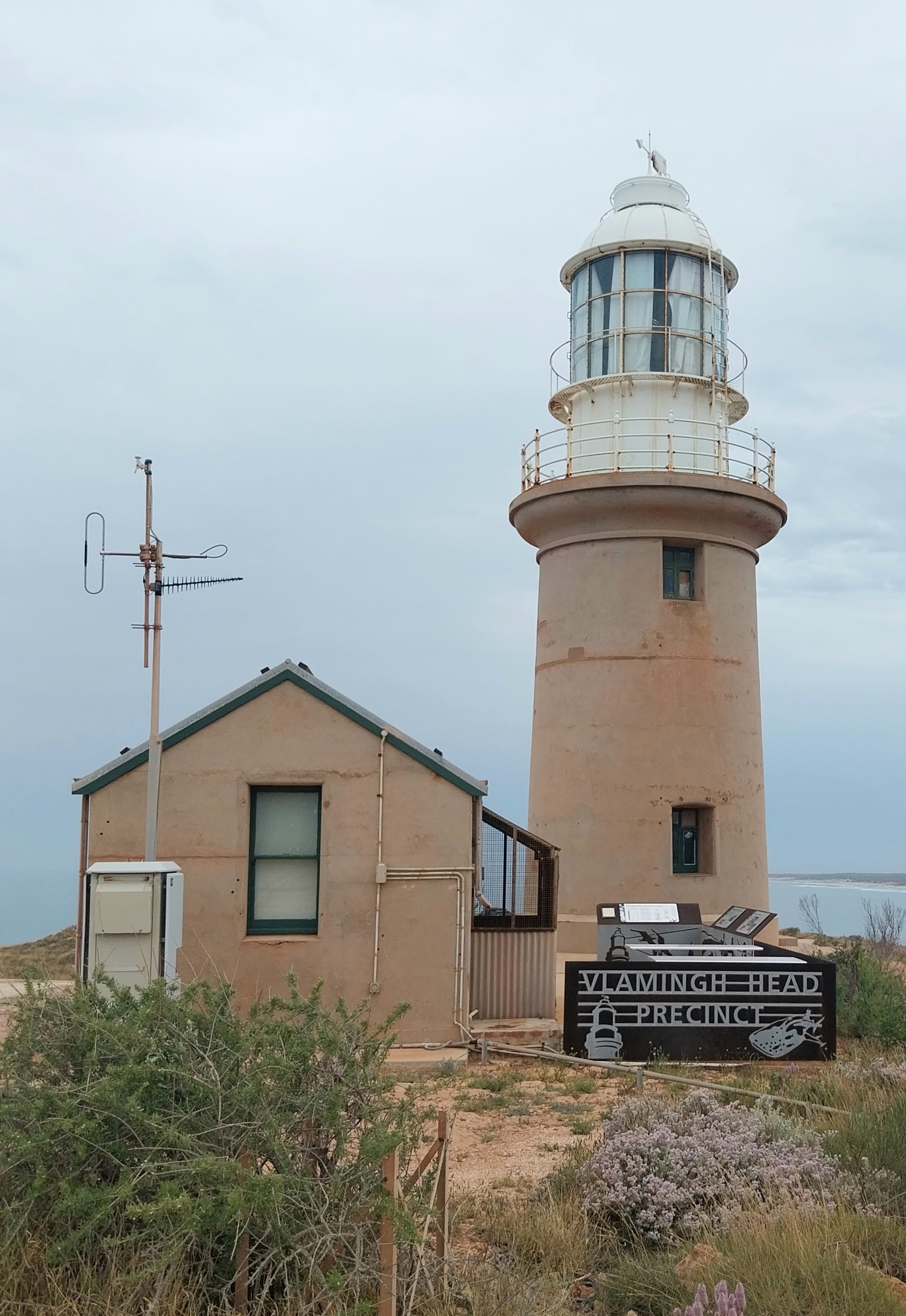
The lighthouse at Vlamingh Head, near where the SS Mildura was wrecked. Photo: Michael Secomb.
Today the remains of The Mildura can still be seen from the frontal dune and have become a tourist attraction.
It has become the most visible of 1650 known shipwrecks in Western Australia, making it the ‘shipwreck coast’, with 103 wrecks protected under state or federal legislation. There are believed to be other shipwrecks not yet located.
The Department of Marine Archaeology at the Western Australian Museum is responsible for maintaining a database and managing the wrecks lying offshore and in inland rivers and estuaries for both the state of Western Australia and the Commonwealth Government.
Many of the shipwrecks were Dutch, and the Australian Netherlands Committee on old Dutch East India Company (VOC) provides information on Dutch ships lost on the coast.
The Abrolhos Islands off Geraldton and the Ningaloo Reef south of Exmouth are notorious ship traps, while further south there are several wrecks off Rottnest Island and the Swan River in Perth contains at least 37 shipwrecks.
Space makes it impossible to tell the stories of all the shipwrecks, but notable ones can be highlighted.
It is possible there are older shipwrecks which have never been recorded. Chinese ships sailed near Timor in the early 1400s, Portuguese vessels were based in Timor in the 15th century and Macassans from Java sailed to northern Australia annually from the 15th century.
These visits have been covered in earlier episodes of this series, ‘Who Really Discovered and Explored Australia?’, and can be found by searching the menu of previous posts.
THE TRYALL
The first known shipwreck on the Australian mainland was The Tryall in 1622, a British East India ship which went aground on the Tryall Rocks near the Monte Bello Islands off Karratha.
Launched in 1621, The Tryall was owned by the British East India Company and commanded by Captain John Brooke. Her crew were the first English to sight land on the Australian continent.
The East India Company had told its captains to sail south of 35 degrees South from Cape Town en route to the East Indies as this route, known as the Brouwer Route, used the Roaring Forties to save time on voyages. Brooke had never sailed on this route before, or been to Batavia in modern Indonesia.
The Tryall (or Trial) left Cape Town on March 19, 1622 and sighted the Australian coast on May 1.
Brooke mistook Point Cloates about 100 kilometres south-south-west of North West Cape on the mainland for an island Captain Lenaert Jacobszoon and Supercargo Willem Janszoon in the Dutch East India Company ship Mauritius had found in 1618, which is now known as Barrow Island.
Janszoon had been the first European to land on Australian soil on February 26, 1606, at the Pennefather River on the western shore of Cape York in Queensland.
Brooke and his crew had made the common navigational error of having sailed too far east, before it was possible to accurately fix longitude.
Brooke turned north, running into winds which delayed his progress. On May 25, 1622, at about 10-11pm, The Tryall struck uncharted submerged rocks about 32 kilometres north-west of the Monte Bello Islands, about eight kilometres north of Barrow Island. The reef is now named Tryall Rocks.

By Moondyne at English Wikipedia - Transferred from en.wikipedia to Commons by Zil using CommonsHelper., Public Domain, https://commons.wikimedia.org/w/index.php?curid=8730946
Captain Brooke, his son John and nine men scrambled into a skiff and 36 other crew members including the ship’s factor Thomas Bright saved a longboat. Brooke sailed separately to Java. Bright and his group went ashore on the Monte Bello Islands and then sailed to Bantam in Java.
A total of 44 survivors reached Bantam on June 21, while the skiff reached Batavia on July 5, after travelling over 1800 kilometres. Of the 143 men who had left England, 94 died.
Brooke blamed incorrect mapping for omitting the rocks and claimed his route was west of his actual path. However, Thomas Bright blamed Brooke’s poor navigation and failure to post a lookout for the shipwreck and accused Brooke of abandoning the bulk of the crew to drown.
Later investigations also claimed Brooke had removed part of the valuable silver cargo, preferring to carry valuable cargo rather than to save the lives of his crew.
In 1934, the site of the shipwreck of The Tryall was identified, while the wreck was found by divers from the Underwater Explorer’s Club in 1969 and examined by divers from the Western Australian Maritime Museum in 1971. Six cannon and eight anchors were identified. Some recovered items including a cannon are in the Shipwreck Galleries at Freemantle.
The Monte Bello Islands were later used by Britain to test nuclear bombs, before being declared a nature reserve.
THE BATAVIA
The Batavia, lost in June, 1629, is the best known of the wrecks. It crashed into the Houtman Abrolhos Islands off Carnarvon. About 300 of the 341 passengers and crew made it to shore.
After the shipwreck, a mutiny and massacre of 125 survivors occurred, led by merchant Jeronimus Cornelisz. The mutineers were eventually defeated by some soldiers.
The commander, Francisco Pelsaert, who had gone searching for water, returned in a rescue vessel and hanged eight of the mutineers on the islands, while two others were put ashore and disappeared. Only 122 of the original 341 made it to Batavia.
I wrote a separate full report about the shocking story of The Batavia, in which some of the survivors murdered many of the others to make their food supplies last longer. After being rescued, eight ring-leaders were summarily hanged without trial on the islands. Books and movies have been produced about this terrible story. See link below:
Other famous shipwrecks include The Vergulde Draack in 1656 and The Zuytdorp in 1712.
VERGULDE DRAACK

By Steve Caffery GDRG - Own work, CC BY-SA 4.0, https://commons.wikimedia.org/w/index.php?curid=45392844
The Vergulde Draack (Vergulde Draek) was was a 41-metre ship of the Dutch East India Company which was lost off the coast of Western Australia on April 28, 1856, with only seven of the 193 crew surviving.
She struck a submerged coral reef off the mid-way point between the modern towns of Seabird and Ledge Point.
About 118 crew are believed to have died in the initil wrecking, while 75 survivors including Captain Pieter Albertszoon made it to shore. Also lost was cargo including 78,600 guilders and trade goods valued at 106,400 guilders.
Nine days later a boat with seven crew members was sent to Batavia to seek help. They arrived at Batavia, about 2600 kilometres away, and a search for survivors was launched, but bad weather prevented the first two ships from landing and others failed. The survivors were never found.
The wreck of the Vergulde Draak was eventually discovered on April14, 1963, about 100 kilometres north of Perth. Artefacts from the wreck are3e in the Freemantle Maritime Museum.
THE ZUYTDORP
The Zuytdorp was a trading ship of the Dutch East India Company which left the Netherlands for Batavia on August 1, 1711, carrying a load of silver coins.
The Zutydorp did not arrive and was never heard from again. No search was made because it was unclear if it had been wrecked or stolen by pirates.
There is speculation, supported by DNA studies, that survivors may have lived with local Aboriginal communities, but another theory is that the genetic links resulted from visits by Malay pearl divers from the Dutch East Indies. Aboriginal people told a farmer about a shipwreck in 1834, but it was never found.
In 1927 wreckage was seen on a clifftop at Tamala station and it was eventually confirmed to be relics from the Zuytdorp. The section of coastline is now named Zuytdorp Cliffs.
A large silver deposit was found in 1967. A team from the Western Australian Museum recovered silver and other materials in 1971. Access to the site was restricted, but some of the silver disappeared.
Phillip Playford’s book, Carpet of Silver: The Wreck of the Zutydorp, won the Western Australian Premier’s Book Award in 1996. Historian Bill Bunbury also devoted a chapter to the Zuytdorp in Caught in Time: Talking Australian History. The Western Australian Museum holds a 500-page Zuytdorp Research Compendium.
ZEE WIJK
In 1727, the Zee wijk, a VOC ship, wrecked on the Houtman Abrolhos. The crew landed, along with supplies and a hoard of silver cargo.
The crew discovered the remains of a Dutch ship near their camp, including artefacts such as bottles, suggesting the previous crew had survived for some time.
This may have been the missing Dutch ship Ridderschap van Holland, which left the Cape of Good Hope on February 5, 1694, with 300 people on board and disappeared. Or it could have been from Fortuyn, which disappeared in 1724. John Lort Stokes, Captain of The Beagle, also saw these artefacts in 1840. Guano mining on the island destroyed the artefacts in the early 20th century.
A longboat was sent to get help from Batavia, but never arrived and disappeared. The crew built a larger boat from salvaged timbers, loaded everyone and the silver and sailed to Batavia in a month.
HMAS SYDNEY AND HSK KORMORAN

HMAS Sydney in 1936. By Green, Allan C., 1878-1954, photographer. - https://find.slv.vic.gov.au/permalink/61SLV_INST/156d4cp/alma9916488333607636, Public Domain, https://commons.wikimedia.org/w/index.php?curid=131950546
In World War II, HMAS Sydney and the German cruiser HSK Kormoran fought a battle off Steep Point in Shark Bay in Western Australia on November 19, 1941, which caused both ships to sink.
The Kormoran, which was heavily-armed, but disguised as a merchant ship to stealthily sink undefended shipping, opened fire first and damaged the bridge and forward turrets of The Sydney.
The battle only last half an hour, but both ships were heavily damaged and sank during the night. The entire 645 crew of The Sydney died, making it the largest loss of life in Australian Navy history.
The complete loss of The Sydney’s crew meant the only accounts came from survivors of The Kormoran’s crew. Out of a crew of 393 (or 399 according to one source), 78 died on The Kormoran. The British merchant ship HMAS Centaur rescued 317 of the Kormoran’s crew.
The wrecks of the two ships were rediscovered in March, 2008, about 100 nautical miles off the coast. Kormoran is lying at a depth of 2560 metres and Sydney is 12 nautical miles away at 2470 metres depth. There is a memorial to the crew of The Sydney at Geraldton in WA.
RECORDS OF THE SHIPWRECKS
The Marine Archaeology Association of Australia and the Museum of Western Australia maintain comprehensive records of shipwrecks in the state. See the links below for details of every wreck:
https://shipswreckwa.com
https://museum.wa.gov.au
Following is an except of the earliest of the West Australian shipwrecks.
As mentioned above, the first known wreck on the Western Australian coast was The Tryall in 1622, a British East India ship wrecked on the Tryal Rocks near the Monte Bello Islands.
1629, The Batavia, the best known of the wrecks, is on the Houtman Abrolhos islands.
1656, Verguide Draeck, VOC ship near Ledge Point.
1712, Zuytdorp, wrecked north of Kalbarri.
1727, Zee wijk, VOC ship wrecked on the Houtman Abrolhos.
1816, Portuguese – Correio da Azia ,bound for Macau.
1824, Belinda, coastal brig at Middle Island, Esperance.
1829, Macquis of Anglesea, at Freemantle.
1830, James, coastal trader, at Owen Anchorage south of Freemantle.
1830, Emily Taylor, brig blown ashore near Freemantle.
1830, Cumberland, British ship south of Hamelin Bay.
1839, Elizabeth, Australian barque near Cottesloe.
1839, Lancer, French barque near Stragglers Reef, Freemantle.
1839, North America, wooden whaler at Koombana Bay.
1840, Samuel Wright, American whaler, beached at Koombana Bay.
1841, Perseverance, French whaler, on Dirk Hartog Island.
1841, James Matthews, wooden brig and former slave ship, Woodman Point.
1842, Ocean Queen, British barque, on the Abrolhos.
1844, Cervantes, wooden whaling barque at Cervantes.
1849, Apenteur, British brig, Hassell Beach in Cheyne Bay.
1850 ,Wave, Australian brig, Cheyne Bay.